当前你的浏览器版本过低,网站已在兼容模式下运行,兼容模式仅提供最小功能支持,网站样式可能显示不正常。
请尽快升级浏览器以体验网站在线编辑、在线运行等功能。
1687:Buggy Sat
题目描述
Discovery Co. ltd. builds a satellite using a new kind of an intelligent camera. The camera has special software to detect cities and roads from an image, and is also able to detect every region (which is a connected part of surface), bounded by a series of connected roads with no other region inside. Using this technology, the satellite is able to compress the picture before sending it. The compressed format of a picture is the city locations and its regions.
Discovery has launched the satellite, without testing the software completely. So, after a while, they received some buggy pictures which includes one more extra region: the outer region. The outer region is the region of the plane enclosing every other region (which has infinite area). Further analysis shows that all images sent have the following properties:
1.All cities, in the image, have at least two roads to the other cities.
2.There is a path connecting every pair of cities.
3.There is at most one road between each pair of cities.
4.Roads do not cross each other except at the cities.

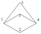
The above Figure shows a sample image received (see sample input).
You are to write a program to read a buggy image and report the outer region.
Discovery has launched the satellite, without testing the software completely. So, after a while, they received some buggy pictures which includes one more extra region: the outer region. The outer region is the region of the plane enclosing every other region (which has infinite area). Further analysis shows that all images sent have the following properties:
1.All cities, in the image, have at least two roads to the other cities.
2.There is a path connecting every pair of cities.
3.There is at most one road between each pair of cities.
4.Roads do not cross each other except at the cities.

The above Figure shows a sample image received (see sample input).
You are to write a program to read a buggy image and report the outer region.
输入解释
The first line of the input consists of a single integer N (1 <= N <= 20), which is the number of test cases. The test cases appear with no blank lines in between. The first line of each test case consists of the number of cities (between 1 and 50) followed by pairs of integers (x, y) which are location of cities (each pair in one line), followed by number of faces in a separate line (between 1 and 50), followed by face information on each line. Face information consists of number of cities making the face and the city numbers in clockwise (or counterclockwise) order.
输出解释
There should be a single line containing the boundary face number for each test case, with no blank lines in between.
输入样例
1
5
2 6
4 4
4 7
8 6
4 10
3
4 1 2 4 3
4 1 3 4 5
4 1 2 4 5
输出样例
3
最后修改于 2020-10-29T06:11:09+00:00 由爬虫自动更新
共提交 0 次
通过率 --%
| 时间上限 | 内存上限 |
| 1000 | 10000 |
登陆或注册以提交代码