当前你的浏览器版本过低,网站已在兼容模式下运行,兼容模式仅提供最小功能支持,网站样式可能显示不正常。
请尽快升级浏览器以体验网站在线编辑、在线运行等功能。
3103:Shoring Up the Levees
题目描述
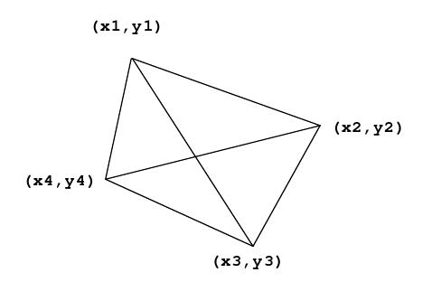
The tiny country of Waterlogged is protected by a series of levees that form a quadrilateral as shown below:

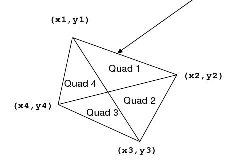
The quadrilateral is defined by four vertices. The levees partition the country into four quadrants. Each quadrant is identified by a pair of vertices representing the outside edge of that quadrant. For example, Quadrant 1 shown below is defined by the points (x1, y1) and (x2, y2) .

It happens very often that the country of Waterlogged becomes flooded, and the levees need to be reinforced, but their country is poor and they have limited resources. They would like to be able to reinforce those levees that encompass the largest area first, then the next largest second, then the next largest third, and the smallest area fourth.
Help Waterlogged identify which quadrants are the largest, and the length of the levees around them.

The quadrilateral is defined by four vertices. The levees partition the country into four quadrants. Each quadrant is identified by a pair of vertices representing the outside edge of that quadrant. For example, Quadrant 1 shown below is defined by the points (x1, y1) and (x2, y2) .

It happens very often that the country of Waterlogged becomes flooded, and the levees need to be reinforced, but their country is poor and they have limited resources. They would like to be able to reinforce those levees that encompass the largest area first, then the next largest second, then the next largest third, and the smallest area fourth.
Help Waterlogged identify which quadrants are the largest, and the length of the levees around them.
输入解释
here will be several sets of input. Each set will consist of eight real numbers, on a single line. Those numbers will represent, in order:
X1 Y1 X2 Y2 X3 Y3 X4 Y4
The four points are guaranteed to form a convex quadrilateral when taken in order -- that is, there will be no concavities, and no lines crossing. Every number will be in the range from -1000.0 to 1000.0 inclusive. No Quadrant will have an area or a perimeter smaller than 0.001. End of the input will be a line with eight 0.0's.
输出解释
For each input set, print a single line with eight floating point numbers. These represent the areas and perimeters of the four Quadrants, like this:
A1 P1 A2 P2 A3 P3 A4 P4
Print them in order from largest area to smallest -- so A1 is the largest area. If two Quadrants have the same area when rounded to 3 decimal places, output the one with the largest perimeter first. Print all values with 3 decimal places of precision (rounded). Print spaces between numbers. Do not print any blank lines between outputs.
输入样例
1 2 1 5 5 2 2 0
3.5 2.2 4.8 -9.6 -1.2 -4.4 -8.9 12.4
0.0 0.0 0.0 0.0 0.0 0.0 0.0 0.0
输出样例
5.100 11.459 3.400 9.045 0.900 6.659 0.600 4.876
44.548 38.972 21.982 25.997 20.342 38.374 10.038 19.043
来自杭电HDUOJ的附加信息
| Recommend | gaojie |
最后修改于 2020-10-25T23:00:04+00:00 由爬虫自动更新
共提交 0 次
通过率 --%
| 时间上限 | 内存上限 |
| 2000/1000MS(Java/Others) | 32768/32768K(Java/Others) |
登陆或注册以提交代码